|
While fishing
was the principal occupation of the people of Renews for four centuries, fishermen also built houses, flakes, boats, and furniture.
The fine buildings and unique architectural features still existing in Renews provide a great example of the skills and creativity
of these craftsmen.
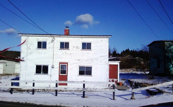
The Newfoundland Salt Box built in the Georgian style is its own architectural paradigm. A traditional
folk house type all over Newfoundland, the Salt Box style, named for its shape, which resembled the boxes used for shipping
salt to Newfoundland, was one of the earliest forms of house construction. The Salt Box traditionally had a shorter steep
roof line in front and a longer steep slope in back. The house, therefore, looked bigger from the front than it actually was.
Salt Boxes featuring a low to mid
slope gable or a lower sloped roof style, are, in many cases, steep gabled houses that have been cut down for ease of roof
maintenance.
This heritage saltbox house overlooks the harbour where The Mayflower landed in 1620 (according
to persistent local legend), hence: The Mayflower. Restoration will begin summer 2014. www.heritage.nf.ca
|